Back Montsoreau ACE Montsoreau Afrikaans Montsoreau ALS ሞንሶረው Amharic Montsoreau ANG مونسورياو Arabic مونسورياو ARZ Montsoreau AST Monsoro Azerbaijani Montsoreau BAR
Montsoreau | |
|---|---|
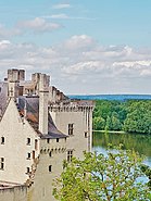
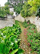
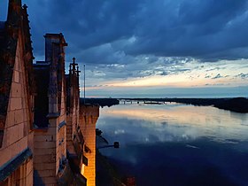
Top to bottom, left to right: Panoramic view of the village from the Loire; Château de Montsoreau-Museum of Contemporary Art; Typical street of Monstoreau listed among The Most Beautiful Villages of France (Les Plus Beaux Villages de France; Sunset in Montsoreau from the Château de Montsoreau-Museum of Contemporary Art | |
| Coordinates: 47°12′59″N 0°03′25″E / 47.2164°N 0.0569°E | |
| Country | France |
| Region | Pays de la Loire |
| Department | Maine-et-Loire |
| Arrondissement | Saumur |
| Canton | Saumur |
| Intercommunality | CA Saumur Val de Loire |
| Government | |
| • Mayor (2020–2026) | Jacky Marchand[1] |
| Area 1 | 5.19 km2 (2.00 sq mi) |
| Population (2021)[2] | 417 |
| • Density | 80/km2 (210/sq mi) |
| Time zone | UTC+01:00 (CET) |
| • Summer (DST) | UTC+02:00 (CEST) |
| INSEE/Postal code | 49219 /49730 |
| Elevation | 27–88 m (89–289 ft) (avg. 36 m or 118 ft) |
| 1 French Land Register data, which excludes lakes, ponds, glaciers > 1 km2 (0.386 sq mi or 247 acres) and river estuaries. | |
Montsoreau (French pronunciation: [mɔ̃sɔʁo] ⓘ) is a commune of the Loire Valley in the Maine-et-Loire department in western France on the Loire, 160 km (99 mi) from the Atlantic coast and 250 km (160 mi) from Paris. The village is listed among The Most Beautiful Villages of France (French: Les Plus Beaux Villages de France) and is part of the Loire Valley UNESCO World Heritage Site.
Montsoreau was identified under the name Restis (rope or fishnet) at the end of classical antiquity as a port on the Loire at the confluence of the Loire and the Vienne. It has taken its name Mount Soreau (Mont Soreau) from a rocky promontory situated in the riverbed of the Loire and surrounded by water on top of which was built a fortress in 990. There have been three major buildings on this promontory, a Gallo-Roman temple or administrative building, a fortified castle, and a Renaissance palace.
Montsoreau was, until the seventeenth century, a center of jurisdiction and the seigneury of Montsoreau stretched from the river Loire to Seuilly-l'Abbaye and Coudray castle in the south. After the French Revolution, the exploitation of a building stone, the tuffeau stone, abruptly increased its population of 600 inhabitants to more than 1000, maintained during the first half of the nineteenth century. This stone, easy to work, was gradually exhausted, and the population decreased to stabilize again around 600 people. Montsoreau then concentrated its activities on agriculture, wine and river trade until the end of the nineteenth century. During the Twentieth century, Montsoreau has seen river trade replaced by terrestrial trade and the rise of a tourism economy.
- ^ "Répertoire national des élus: les maires" (in French). data.gouv.fr, Plateforme ouverte des données publiques françaises. 13 September 2022.
- ^ "Populations légales 2021". The National Institute of Statistics and Economic Studies. 28 December 2023.
© MMXXIII Rich X Search. We shall prevail. All rights reserved. Rich X Search


